|
前言
在将多个CAD图纸合并到一张图上,或者实现图形的数据库管理时,往往会面临数据坐标转换和格式转换的问题,当前主流是统一用shapefile或者gdb地理数据库等方式进行管理。 CAD转shapefile有很多种方式,以下方法基于ArcGIS的arcpy工具包进行,可以实现批量CAD文件转gdb或者shp格式。
算法流程
arcpy是ArcGIS的python工具包,如果电脑有安装ArcGIS或者ArcGIS Pro,在默认安装路径下有安装arcpy,python运行的时候选择ArcGIS安装的python程序运行。
ArcGIS提供help文档链接: https://pro.arcgis.com/zh-cn/pro-app/2.6/tool-reference/conversion/cad-to-geodatabase.htm
具体流程是先将CAD文件(格式为dwg)导入创建的地理数据库中,然后将地理数据库的文件导出成shapefile文件,调用的arcpy的主要函数为: CreateFileGDB_management(创建地理数据库) CADToGeodatabase_conversion(CAD导入地理数据库) FeatureClassToShapefile_conversion(导出成shapefile) 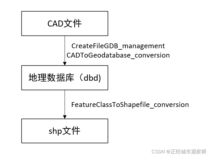
import arcpy
import os
# 自定义输入文件路径
defaultpath=r"D:\03程序开发小工具"
# 输入CAD文件名称
CADname='test'
# 定义工作空间
arcpy.env.workspace = defaultpath
# CAD文件路径
input_cad_dataset =os.path.join(defaultpath,'cad',CADname+'.dwg')
# gdb文件路径
out_gdb_path = os.path.join(defaultpath,'gdb',CADname+'.gdb')
# 要素集文件名称
out_dataset_name = CADname
# CAD转shp坐标比例
reference_scale = "1"
# 先创建一个gdb地理数据库
arcpy.CreateFileGDB_management(os.path.join(defaultpath,'gdb'), CADname+'.gdb')
# 将CAD文件导入到gdb地理数据库,新建一个要素集
arcpy.CADToGeodatabase_conversion(input_cad_dataset, out_gdb_path, out_dataset_name, reference_scale)
# 切换工作空间到gdb中
arcpy.env.workspace = out_gdb_path
# 获取gdb中的文件列表
datasets = arcpy.ListDatasets(feature_type='feature')
# 输入shp文件的保存路径
output_shp_path=os.path.join(CADname+defaultpath,'shp')
datasets = [''] + datasets if datasets is not None else []
# 获取每个地理数据库中的要素集
for ds in datasets:
for fc in arcpy.ListFeatureClasses(feature_dataset=ds):
path = os.path.join(arcpy.env.workspace, ds, fc)
# print(path)
outfc = arcpy.ValidateTableName(fc)
# print(outfc)
# 将要素集里的要素转为shp文件
arcpy.FeatureClassToShapefile_conversion(outfc, output_shp_path)
至此,就生成了从CAD转shp的代码,但是转换后的shp是没有定义坐标系的,根据CAD的坐标进行坐标系的定义。
|