| uniapp 根据定位实现地图绘制轨迹 | 您所在的位置:网站首页 › 高德怎么生成轨迹记录 › uniapp 根据定位实现地图绘制轨迹 |
uniapp 根据定位实现地图绘制轨迹
|
目录 一、实时定位并保存经纬度(推荐使用uni.getLocation ) 二、根据已有的经纬度数组渲染线(polyline)以及标记点(markers) 三、前后台获取经纬度并展示到地图上(uni.startLocationUpdateBackground) 1、获取权限 2、获取定位 3、使用 4、结束定位 一、实时定位并保存经纬度(推荐使用uni.getLocation )uniapp-getLocation
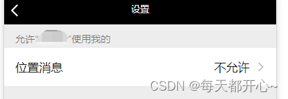
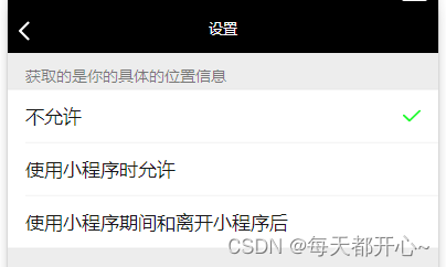
方法示例 getLocation(id) { const _this = this; _this.coordinates.driverTaskId = id uni.getLocation({ type: 'gcj02', // (!!!必需)默认为 wgs84 返回 gps 坐标,gcj02(更准确) 返回可用于 wx.openLocation 的坐标 isHighAccuracy: true, //开启高精度定位(!!!必需) success: function(res) { _this.coordinates.latitude = res.latitude // 当前位置纬度 _this.coordinates.longitude = res.longitude // 当前位置经度 console.log(_this.coordinates, 'coordinates') }, fail: function(error) { uni.showToast({ title: '无法获取位置信息!无法使用位置功能', icon: 'none', }) } }); },注:高德(getRegeo)获取当前位置返回的坐标采用的是wgs84 ,如果需要经纬度来渲染到地图上,尽量不要用高德的。 二、根据已有的经纬度数组渲染线(polyline)以及标记点(markers)使用uni-app的map组件 uniapp-map 下面是我封装的一个map组件 回显轨迹(点击进入这个组件,前提是需要传轨迹点位) 查看轨迹 // 查看轨迹方法 lookTrajectory(item) { getTrajectory(item.id).then(res => { if (res.data.code == 200) { const data = JSON.stringify(res.data.data) console.log(data) uni.navigateTo({ url: `/pages/task/trajectory/trajectory?points=${data}&status=${item.taskStatus}&endLatitude=${item.endLatitude}&endLongitude=${item.endLongitude}&startLatitude=${item.startLatitude}&startLongitude=${item.startLongitude}&id=${item.id}` }); } }) }, export default { data() { return { latitude:'', longitude:'', polyline: [], // 线 points:[], showmap:false, markers:[], // 标记点 }; }, onLoad(event) { uni.showLoading({ title: '地图加载中', // mask: true }) this.points = JSON.parse(event.points) // 通过navigateTo传过来的数据 this.latitude=this.points[0].latitude this.longitude=this.points[0].longitude const length= this.points.length-1 const taskline={ points: this.points, color: "#5A97FF", width: 10, // width必须填 不然会报错 arrowLine:true // 是否有箭头 } const markers0={ latitude:this.points[0].latitude, longitude:this.points[0].longitude, id:0, iconPath:'/static/images/task/startpoint.png', width:40, height:50 } const markers1={ latitude:this.points[length].latitude, longitude:this.points[length].longitude, id:1, iconPath:'/static/images/task/endpoint.png', width:40, height:50 } this.markers.push(markers0) this.markers.push(markers1) console.log(this.markers) this.polyline[0]=taskline this.showmap=true; setTimeout(() => { uni.hideLoading() }, 1000) } } 三、前后台获取经纬度并展示到地图上(uni.startLocationUpdateBackground)uni.startLocationUpdateBackground 前提:由于项目需求,只有前台获取地址已经不满足了,因此找到了这个方法,前后台都可以获取地址 manifest.json 文件中 "mp-weixin" 里添加:onLocationChange和startLocationUpdateBackground是搭配使用的 "permission" : { "scope.userLocation" : { "desc" : "获取当前位置信息" }, "scope.userLocationBackground":{ "desc" : "获取您的后台位置" } }, "requiredPrivateInfos":["getLocation","onLocationChange","startLocationUpdateBackground" ], "requiredBackgroundModes":["location"] 1、获取权限 // 初次位置授权 getAuthorize() { return new Promise((resolve, reject) => { uni.authorize({ scope: 'scope.userLocationBackground', success: () => { resolve() // 允许授权 }, fail: () => { reject() // 拒绝授权 }, }) }) }, // 用户首次拒绝授权后(考虑是误点击),弹框提示是否手动打开位置授权 openConfirm() { return new Promise((resolve, reject) => { uni.showModal({ title: '请求授权当前位置', content: '我们需要获取地理位置信息', success: res => { if (res.confirm) { uni.openSetting().then(res => { console.log('想看看:', res) if (res[1].authSetting['scope.userLocationBackground'] === true) { resolve() // 打开地图权限设置 } else { reject() } }) } else if (res.cancel) { reject() } }, }) }) },
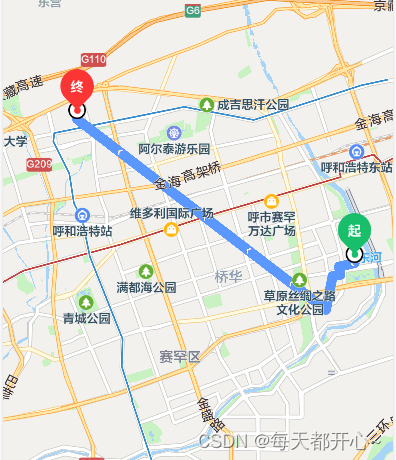
这样就可以啦,可以实时刷新了 over over 如有错误请大家指正!!!! 补充:完整代码如下: 调用组件页面:这里面css样式没有放上去 查看轨迹 开始配送 暂无任务~ import { getTask, gettaskInfo, addTrajectory, getTrajectory, cancelTask, deleteTask, } from "@/api/cargo.js"; import { driverCancel, startTransportation, } from "@/api/drivertask.js"; import cache from "@/utils/cache.js"; // 获取token export default { name: "tabbar-task", props: { tasklist: Array, taskstatus: String, param: Object, }, data() { return { taskform: {}, tasklistArr: [], timer: null, // 定时器 gaodekey: '', // 高德的key coordinates: { latitude: '', //纬度 longitude: '', // 经度 taskId: '', // 任务id }, //坐标系 weChatUserId: '', // 微信用户id(司机) userRole: '', // 用户权限 货主还是司机 sysUserId: '', //货主id }; }, beforeCreate() { uni.showLoading({ mask: true, title: '正在加载中...', }) }, mounted() { this.weChatUserId = cache('user_token', null) this.sysUserId = cache('sys_user', null) this.userRole = cache('user_role', null) this.tasklistArr = JSON.parse(JSON.stringify(this.tasklist)) setTimeout(() => { uni.hideLoading() }, 500) if (this.userRole == 'company') { this.refreshOwnerList() } }, watch: { tasklist: { immediate: true, // 这句重要 handler(val) { this.tasklistArr = val; }, }, }, methods: { // 开始任务 startTask(id) { // 开始配送 startTransportation是接口 // export function startTransportation(id) { // return request({ // url: `/driver/start_transportation/${id}`, // 'method': 'POST' // }) // } startTransportation(id).then(res => { if (res.data.code == 200) { this.refreshDriverList() // 更新列表 // 先获取位置权限 this.getAuthorize() .then(() => { console.log("同意获取位置权限") // 同意后获取 this.getLocation(id) }) .catch(() => { // 不同意给出弹框,再次确认 this.openConfirm() .then(() => { console.log("同意获取位置权限") this.getLocation(id) }) }) } }) }, // 查看轨迹 lookTrajectory(item) { getTrajectory(item.id).then(res => { if (res.data.code == 200) { const data = JSON.stringify(res.data.data) console.log(data) uni.navigateTo({ url: `/pages/task/trajectory/trajectory?points=${data}&status=${item.taskStatus}&endLatitude=${item.endLatitude}&endLongitude=${item.endLongitude}&startLatitude=${item.startLatitude}&startLongitude=${item.startLongitude}&id=${item.id}` }); } }) }, // 初次位置授权 getAuthorize() { return new Promise((resolve, reject) => { uni.authorize({ scope: 'scope.userLocationBackground', success: () => { resolve() // 允许授权 }, fail: () => { reject() // 拒绝授权 }, }) }) }, // 用户首次拒绝授权后(考虑是误点击),弹框提示是否手动打开位置授权 openConfirm() { return new Promise((resolve, reject) => { uni.showModal({ title: '请求授权当前位置', content: '我们需要获取地理位置信息', showCancel: false, success: res => { if (res.confirm) { uni.openSetting({ success(res) { resolve() // 打开地图权限设置 } }) } else if (res.cancel) { reject() } }, }) }) }, // 获取当前位置 getLocation(id) { const _this = this; _this.coordinates.taskId = id uni.startLocationUpdateBackground({ type: 'gcj02', success: (res) => { uni.onLocationChange((data) => { /* _this.coordinates.latitude = data.latitude // 当前位置纬度 _this.coordinates.longitude = data.longitude // 当前位置经度 addTrajectory(_this.coordinates) */ //获取当前时间 var currentTime = new Date().getTime(); //获取上次执行的时间 var oldTime = uni.getStorageSync('oldTime'); console.log(currentTime, 'currentTime') console.log(oldTime, 'oldTime') //获取上次保存的位置信息 // var oldLocation = wx.getStorageSync('oldLocation'); //将经纬度拼接 // var newLocation = data.latitude + "" + data.longitude; //判断当前间隔时间超过5s if (currentTime - oldTime > 5000) { console.log(data, '传递经纬度') //缓存当前最新位置 // uni.setStorageSync('oldLocation', newLocation); //缓存当前执行的时间 uni.setStorageSync('oldTime', currentTime); _this.coordinates.latitude = data.latitude // 当前位置纬度 _this.coordinates.longitude = data.longitude // 当前位置经度 addTrajectory(_this.coordinates) } }); }, fail: error => { console.log(error) uni.showToast({ title: '无法获取位置信息!无法使用位置功能', icon: 'none', }) } }); }, }, } trajectory文件就是封装的map组件import { getTrajectory } from "@/api/drivertask.js"; export default { data() { return { latitude:'', longitude:'', polyline: [], // 线 points:[], showmap:false, markers:[], // 标记点 taskid:'', // 任务id taskstatus:'', // 任务状态 timer:null, // 定时器 endLatitude:'', endLongitude:'', startLatitude:'', startLongitude:'', }; }, onLoad(event) { uni.showLoading({ title: '地图加载中', // mask: true }) this.endLatitude=event.endLatitude this.endLongitude=event.endLongitude this.startLatitude=event.startLatitude this.startLongitude=event.startLongitude this.points = JSON.parse(event.points) this.taskid = event.id this.taskstatus = event.status this.setPolyline() this.showmap=true; setTimeout(() => { uni.hideLoading() }, 1000) }, mounted() { if(this.timer){ clearInterval(this.timer) }else{ console.log(this.taskstatus) if(this.taskstatus==5){ this.timer = setInterval(() => { console.log('正在运输。。。。。') this.lookTrajectory(); }, 5000); } } }, beforeDestroy() { clearInterval(this.timer) }, methods:{ // 查看司机轨迹 lookTrajectory() { getTrajectory(this.taskid).then(res => { if (res.data.code == 200) { const data =JSON.parse(JSON.stringify(res.data.data)) this.points=data console.log(this.points,'获取轨迹经纬度了哦points~') this.setPolyline() } }) // 获取地图轨迹数据点 }, setPolyline(){ this.latitude=this.points[0].latitude this.longitude=this.points[0].longitude const length= this.points.length-1 const taskline={ points: this.points, color: "#5A97FF", width: 10, arrowLine:true } const markers0={ latitude:this.points[0].latitude, longitude:this.points[0].longitude, id:0, iconPath:'/static/images/task/startpoint1.png', width:48, height:61 } const markers1={ latitude:this.points[length].latitude, longitude:this.points[length].longitude, id:1, iconPath:'/static/images/task/endpoint1.png', width:48, height:61 } const markers2={ latitude:this.startLatitude, longitude:this.startLongitude, id:2, iconPath:'/static/images/task/startpoint2.png', width:48, height:61 } const markers3={ latitude:this.endLatitude, longitude:this.endLongitude, id:3, iconPath:'/static/images/task/endpoint2.png', width:48, height:61 } this.markers[0]=markers0 this.markers[1]=markers1 this.markers[2]=markers2 this.markers[3]=markers3 this.polyline[0]= taskline; console.log("改变地图轨迹啦!!!") }, }, } |


【本文地址】
公司简介
联系我们
| 今日新闻 |
| 推荐新闻 |
| 专题文章 |