|
1.数据导入
导入处理完的excel。
1.1导入点数据

益阳给的数据的X、Y是反着的,地理坐标系为2000,中心轴为112.5011822162
资兴Y坐标 去掉38前缀


1.2导入线数据


线数据生成缺少字段,需要通过连接表添加字段属性
 
1.3数据导出
在确认数据没问题后,可以将数据导出成shape文件
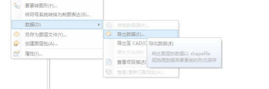
导出到指定的文件夹并做好命名 
2.数据库添加数据
先在测试服查看,清空数据库点表和线表
2.1加载数据

按步骤操作,填充对应字段
在数据库里添加is_deleted、type、flow_type等字段
2.2图层排序查看

手动增加流向,拖动新增线图层,选择flow_type字段,新增类别

污水正向、反向、双向 1-3 蓝色
雨水正向、反向、双向 4-6 绿色
雨污同流正向、反向、双向 7-9
3.发布地图服务
3.1先将数据库注册到gis服务器上
 
3.2发布服务

去重sql
DELETE
FROM
sde.JH_POINT
WHERE
code IN ( SELECT code FROM [sde].[JH_POINT] GROUP BY code HAVING COUNT ( code ) > 1 )
AND OBJECTID NOT IN ( SELECT MIN ( OBJECTID ) FROM sde.JH_POINT GROUP BY code HAVING COUNT ( code ) > 1 )
管线sql
update [sde].[JH_LINE] set is_deleted = 0
update [sde].[JH_LINE] set type = '污水' where code LIKE 'WS%'
update [sde].[JH_LINE] set type = '雨水' where code LIKE 'YS%'
update [sde].[JH_LINE] set type = '雨污合流' where code LIKE 'HS%'
update [sde].[JH_LINE] set age = 1
update [sde].[JH_LINE] set is_open_alarm = 0
update [sde].[JH_LINE] set flow_type = 1 where type = '污水' and flow_directory = 0
update [sde].[JH_LINE] set flow_type =2 where type = '污水' and flow_directory =1
update [sde].[JH_LINE] set flow_type =4 where type = '雨水' and flow_directory =0
update [sde].[JH_LINE] set flow_type =5 where type = '雨水' and flow_directory =1
update [sde].[JH_LINE] set flow_type =7 where type = '雨污合流' and flow_directory =0
|